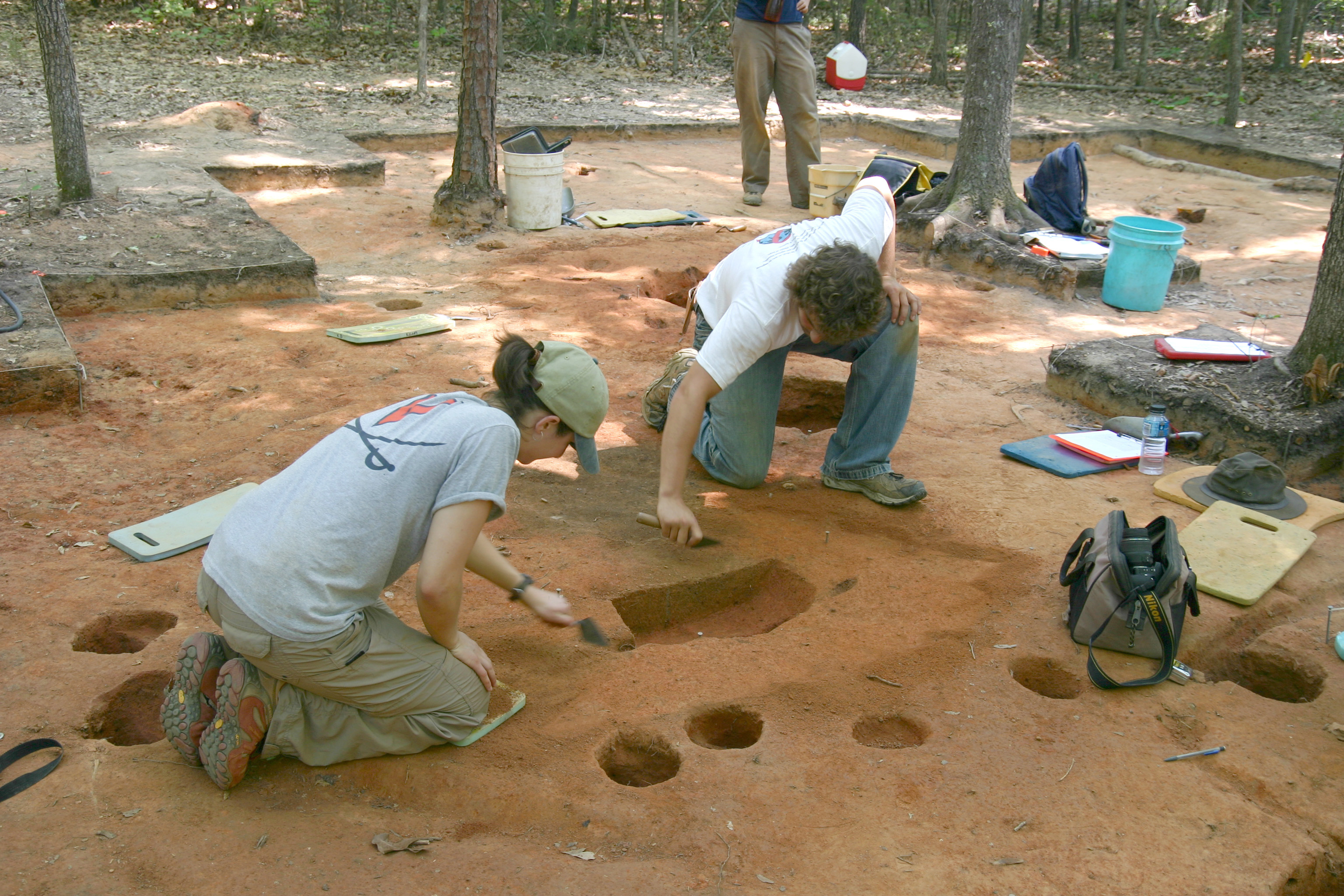
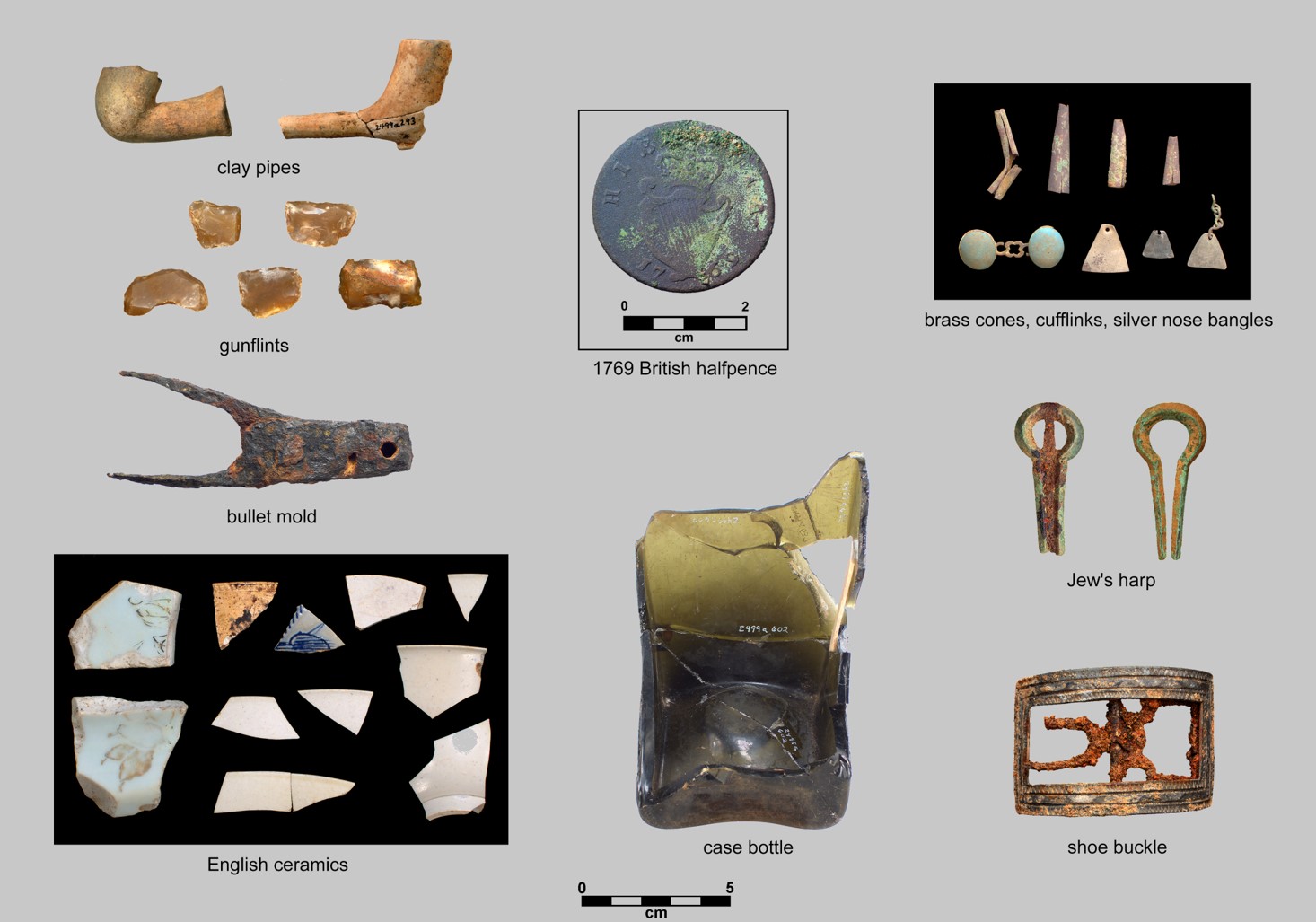
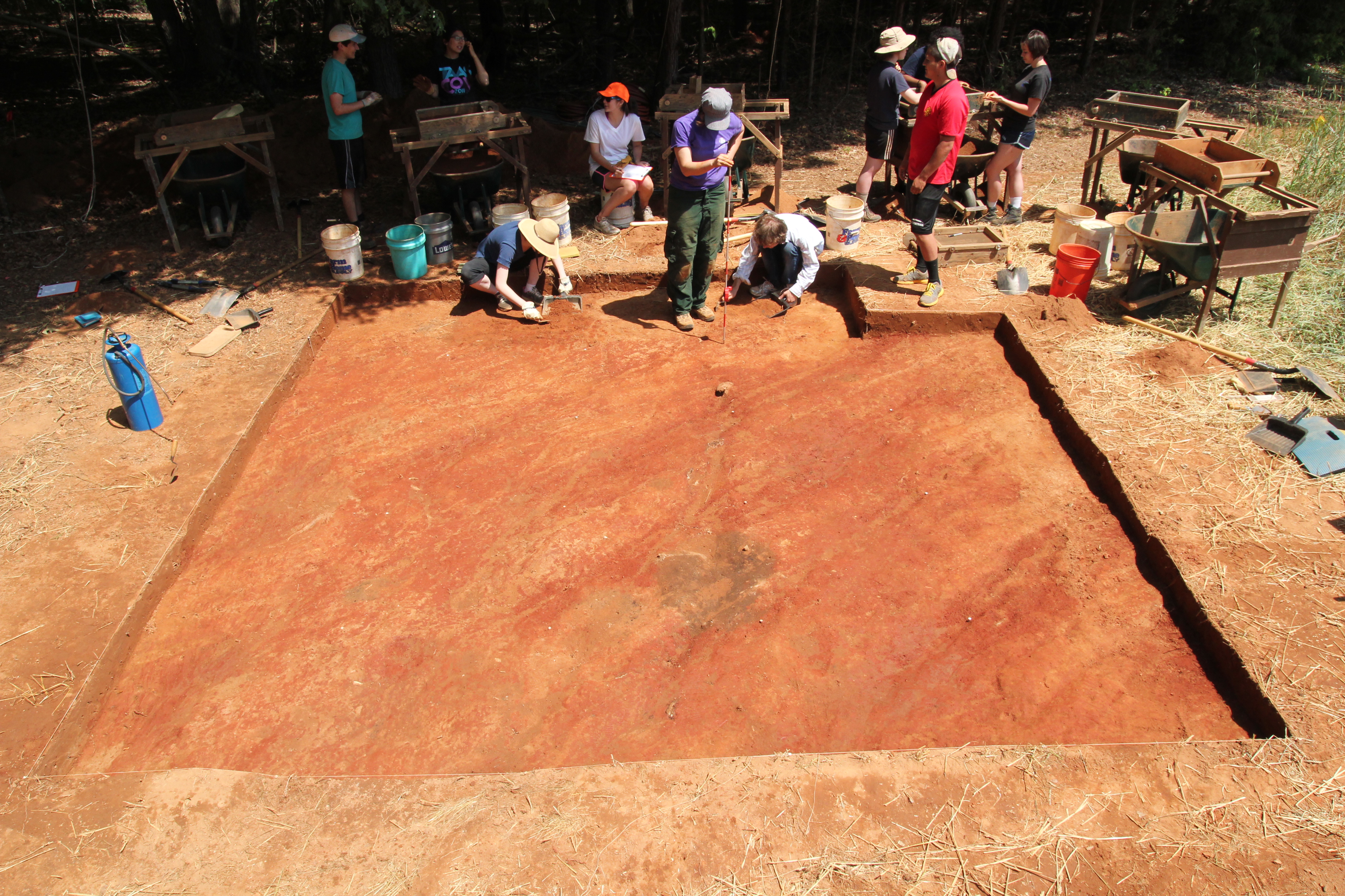
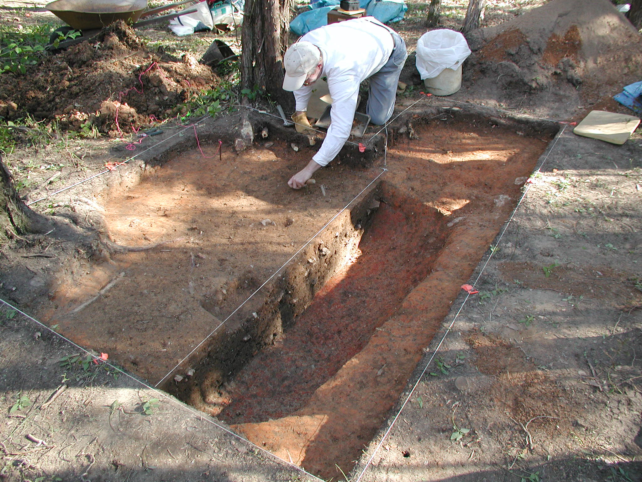
RLA archaeologists conducted excavations at seven Historic Catawba settlements: Nassaw, Weyapee and Charraw Towns (c. 1750-1759), Old Town (c. 1763-1790), the Nisbet Site (c. 1763-1780), Ayers Town (c. 1781-1800), New Town (c.1790-1820), and the Bowers site (c.1800-1820). Read more about the sites, excavations, and findings below.

Nassaw-Weyapee (c. 1750-1759)

Archaeological site 38Yk434 in York County, South Carolina, has been identified as the paired towns of Nassaw and Weyapee by reference to a map drafted in 1756. The site consists of two discrete loci separated by a spring. The name “Nassaw” appears to derive from the Catawban term “Nea Iswa,” which translates as Esaw people or River people. This suggests they were affiliated with the “Yssa” or “Esaw” groups recorded in early Spanish and English accounts. UNC’s Archaeological Field School excavated at Nassaw and Weyapee in 2007 and 2008, resulting in the identification of at least seven house areas. The site was abandoned in 1759 after a devastating smallpox epidemic introduced by Catawba warriors returning from the Quebec campaign of the French and Indian War.

Excavations at Nassaw.
Excavations at Charraw Town.

Charraw Town (c. 1750-1759)

Charraw Town, like Nassaw-Weyapee, was identified by reference to a map drafted in 1756. It is located near the town of Fort Mill, South Carolina. The name “Charraw” can be equated with “Sara” or “Saura,” a seventeenth-century community located on the Dan River near the border between present North Carolina and Virginia. During the early eighteenth century the Charraw lived along the Pee Dee River in South Carolina, having left their homeland to avoid Seneca raids. In the 1730s they moved again to join the Catawba Nation. Like Nassaw and Weyapee Towns, Charraw Town was abandoned in 1759 after a smallpox epidemic introduced by Catawba warriors returning from the French and Indian War. The 2011 UNC Archaeological Field School excavated a house area and a buried midden deposit at Charraw Town.

Old Town (c. 1763-1790)

Catawba Old Town (RLA-SoC 634) was discovered in January 2003 and is named after an adjacent stream depicted on an 1843 land plat as “Old Town Branch.” It is located along an ancient terrace remnant that flanks the Catawba valley. This site has yielded artifacts and contexts that reflect occupations just prior to and following the American Revolution, and it likely represents a Catawba town depicted on Samuel Wyly’s 1764 map of the Catawba Indian Reservation.  The 2003, 2009, 2014, and 2017 UNC Archaeological Field Schools excavated at Catawba Old Town.  Those excavations revealed the remains of five log cabins, a post-in-ground building, and surrounding activity areas.  Archaeological contexts associated with the earlier cabins at the site contained the oldest examples of Catawba “colonoware” ceramics—hand-built earthenware vessels made in English styles and marketed to nearby Euroamerican settlers.

Some of the artifacts found at Old Town.
Excavations at the Nisbet site.

Nisbet Site (c. 1763-1780)

The Nisbet site represents a single post-in-ground structure and interior storage pit that was excavated by the 2014 UNC Archaeological Field School. It provides evidence that some Catawba households continued to construct traditional houses up until the American Revolution, even though most households had transitioned to horizontal cribbed-log houses by this time.

Ayers Town (ca. 1781-1800)

Ayres Town, located on the west side of the Catawba River opposite the mouth of Twelve Mile Creek and just south of the contemporary Catawba Reservation, was first identified as part of a cultural resource survey for a proposed bridge replacement project.  In 2010 RLA staff and UNC Archaeological Field School students identified as many as thirteen domestic structures at Ayers Town, which was one of the main villages occupied by the Catawba Nation after the American Revolution.  The name of the site was inspired by an account of the Lady Henrietta Liston who visited a Catawba town in the winter of 1797.  Liston mentions crossing the Catawba River to visit a town where ‘the Colonel’ resided, who was likely Col. John Ayers.

Excavating a feature at Ayers Town.
Ceramics imported from England found at New Town.

New Town (c. 1790-1820)

New Town was a primary settlement of the Catawba Nation from the late 1700s until about 1820. This site was originally documented in 1935 by Isabelle Baker who interviewed former Catawba chief Samuel Blue. RLA survey and excavation at New Town from 2002 through 2005 resulted in the identification of two hamlets or neighborhoods consisting of multiple cabin loci. The southern hamlet may be the homesite of Sally New River and General Jacob Ayers, a veteran of the American Revolution. Members of New Town households practiced different economic strategies, which included making pottery to sell, farming, and leasing their land to Euroamericans.

Bowers Site (c. 1800-1820)

The Federal-period Bowers site is a single cabin seat situated atop a high ridge flanking the Catawba alluvial valley. It was probably part of a small Catawba community, called Turkey-head, identified by Robert Mills in 1826. In 2002 RLA archaeologists working at the Bowers site excavated a rectangular cellar pit located adjacent to a Federal period roadbed. English ceramic wares and other associated materials indicate a site occupation during the first two decades of the nineteenth century. Three other cabin seats identified nearby may represent the remainder of the Turkey-head community.

Excavations at the Bowers site.